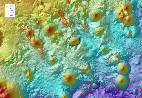
AusSeabed logo
Join our Community
  • About
    • Seabed Mapping
    • Initiatives
    • Collaborators
    • Related Programs
    • Governance
    • Our Community
  • Surveys & Data
    • Bathymetry Coverage
    • National Bathymetry Priorities
    • Data
  • Resources
    • Guidelines
    • Capability Catalogue
    • Systems Available
    • Publications & Presentations
    • Education
    • Permit Information
  • Tools
    • Bathymetry Coverage
    • Upcoming Survey Register
    • On-Site Multibeam Mobilisation Report
    • Seabed Survey Data Model
    • VDatum
    • AusCoastVDT
    • HydrOffice
    • AMUST
    • Survey tool Hydrobib
  • News & Events
    • Upcoming meetings and events
    • Prior meeting outcomes
    • Monthly newsletters

Resources

Tangaroa multibeam. Image credit: National Institute of Water and Atmospheric Research

Guidelines

Scott Nichol on the Southern Surveyor. Photo credit: Michelle Linklater

Capability Catalogue

Investigator in open ocean. Photo credit: Owen Foley & MNF

Systems Available

Publications & Presentations

Deakin University 1st year Marine Biology students learning about sonar mapping aboard the RV Yolla. Photo credit: Dan Ierodiaconou

Education

Permit Information

  • Contact Us
  • Copyright
  • Privacy
AusSeabed acknowledges the traditional owners of the country throughout Australia and their continuing connection to land, sea and community. We pay our respect to them and their cultures and to the elders past and present.