QAX: A Quality Assurance Tool
QAX is an open-source project, jointly steered by AusSeabed, the United States of America National Oceanic and Atmospheric Administration’s Office of Coast Survey (NOAA OCS), and the University of New Hampshire’s Center for Coastal and Ocean Mapping (UNH CCOM). QAX is available on the AusSeabed GitHub (github.com/ausseabed/qax).
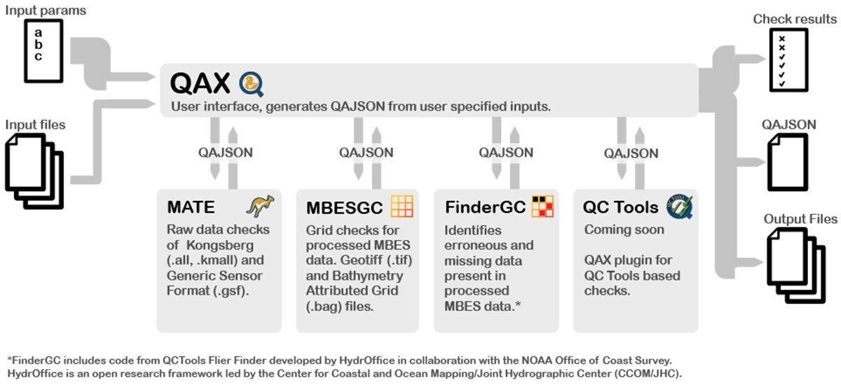
QAX facilitates quality assurance (QA) of multibeam echosounder (MBES) data. It provides an efficient workflow for checking MBES data. The tool standardises QA outputs and assists the technician to perform a robust QA of data.
Three plug-in tools are available through the QAX user interface that facilitate the QA checks.
MATE
- Raw data checks for unprocessed MBES data
- Runs QA checks on .all, .kmall and .gsf files
- Can be used for near-real time decision making
- Matadata and messages are generated to aid downstream processing
MBESGC
- Grid checks for processed MBES data
- Runs QA checks on multiband geotiff files
- Checks data against IHO or HIPP standards
FinderGC (also known as QA Tools)
- Flags erroneous and missing data present in processed MBES data
- Runs QA checks on multiband geotiff files
- Identifies holidays (missing data or holes)
- Identifies erroneous data (fliers or outliers)
QC Tools
- Coming in future release
- QA checks on MBES saved in a BAG file format
Do you need more checks? Tell us what you think of QAX using our feedback form.
How QAX works
QAX runs these QA plug-ins based on user-defined input parameters and input files. After the checks are run, a check results table, QAJSON output and output files are created. The check results table provides near real time decision support QAJSON output contains the provenance and metadata on the check that was run. Additional output files are also created for use in external software packages and enable further analysis of processed multibeam data check results.
QAX was born from collaboration
QAX was born from a collaboration between AusSeabed, the Center for Coastal and Ocean Mapping/Joint Hydrographic Centre (CCOM/JHC) at the University of New Hampshire and the NOAA Office of Coast Survey. The QAX collaboration led to the creation of the first version of the QAX tool to meet the needs of the AusSeabed community. In the future, QAX contributors aim to continue to provide updates to QAX and increase the benefit of the tool to the wider seabed community.
If you are having problems with QAX that can’t be solved after consulting our Training Materials, including the QAX Help Manual, please contact ausseabed@ga.gov.au.