Governance
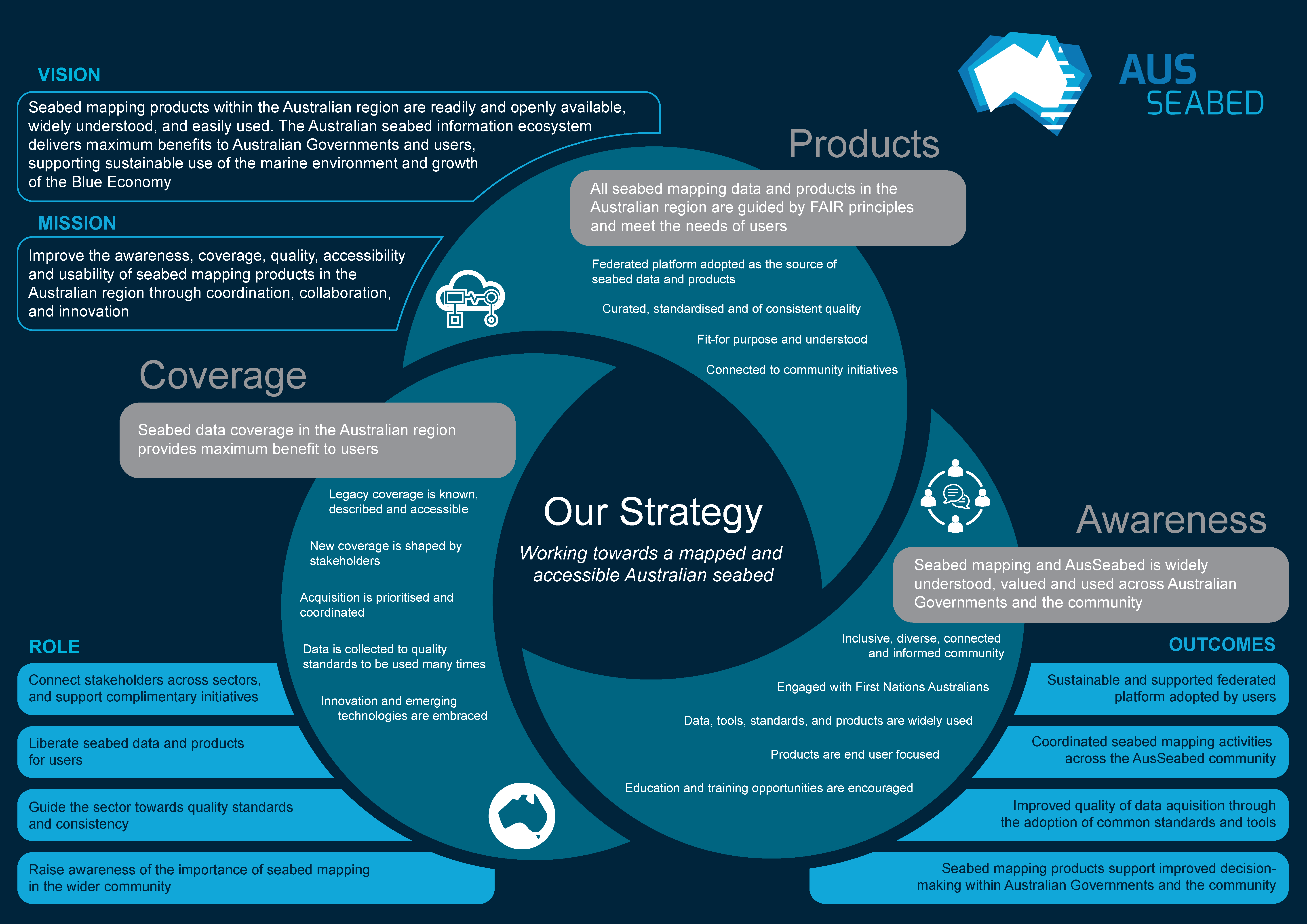
The AusSeabed program is governed by a Steering Committee and an Executive Board. The AusSeabed Strategy and the 2025 Activities Roadmap are living documents developed by the Steering Committee outlining the direction of the program.
The Steering Committee has been established to provide an effective representative governing body of the AusSeabed program. It provides strategic direction and leadership in guiding AusSeabed to best achieve the vision for national seabed mapping data: 'collect once, use many times'. Membership consists of an equal and fair representation of the various sectors that participate in the AusSeabed initiative. The Steering Committee is composed of three standing members (Geoscience Australia, Australian Hydrographic Office and CSIRO Marine National Facility), up to nine other national members and one international member.
The structure of the Steering Committee and the framework under which the Committee operate are guided by the AusSeabed Steering Committee Terms of Reference. Positions on the Committee are elected for a term of two years and a staggered renewal process ensures continuity between committees. More information on this process can be found in the AusSeabed Election Process Standard Operating Procedure. A list of the current Steering Committee members can be found below.
The Executive Board provides an agile, high-level strategic governance function. It advises on the development of, and endorses, the AusSeabed strategic agenda as well as reviews and endorses the work programs put forward by the Steering Committee. The Executive Board actively champion AusSeabed and help the Steering Committee demonstrate and communicate the value of the initiative. The Executive Board is initially composed of Commonwealth Agencies with scope to diversify. The AusSeabed Executive Board Terms of Reference more fully describes its role.
Steering Committee Representatives
Richard Cullen
Australian Hydrographic Office
Steering Committee Chair and Standing member
Richard commenced hydrographic surveying in 1996 as an officer in the Royal Australian Navy (RAN). He was the lead instructor and later managed the RAN Hydrographic School. Experience ranges from Laser Airborne Depth Sounding operations out of Cairns, development of hydrographic standards and conducting quality assurance at the Australian Hydrographic Office. Richard had owned a successful small hydrographic company since 2005 and left the RAN in 2014 to run this full-time until re-engaging with Defence in 2022. Within his company he conducted multidisciplinary surveys, training, and consultancy including capacity building activities in overseas locations. He became a Certified Professional Hydrographic Surveyor (CPHS Level 1) in 2006 and served for 15 years on the Australasian Hydrographic Surveyors Certification Panel (AHSCP). A former Chair of the Surveying & Spatial Sciences Institute (SSSI) Hydrography Commission but now Chair of the AusSeabed Steering Committee and the Ports Australia Hydrographic Surveyors Committee. He is a strong advocate for building capacity and training in the seabed mapping community and has contributed to key community guidelines, including those published through AusSeabed. Richard is Director National Hydrography at the Australian Hydrographic Office, with direct oversight of the HydroScheme Industry Partnership Program, or HIPP as it is best known
Dr Pip Bricher
Geoscience Australia
Standing member
Pip is currently the Director of National Seabed Mapping at Geoscience Australia. Pip’s experience includes international ocean data coordination through the Southern Ocean Observing System and developing policy and technical mechanisms to enable the discovery and re-use of maritime data at the Australian Hydrographic Office. Pip is an excellent communicator and highly experienced in international fora.
Matt Boyd
Commonwealth Scientific and Industrial Research
Standing member
Matt is the team leader of the Geophysical Survey and Mapping team at CSIRO. The team is responsible for the quality collection and management of water column, seafloor, and sub seafloor data off Australia’s only Blue water research vessel the RV Investigator. Matt has 15 years of experience across the spatial sciences including land surveying, high precision engineering measurement, remote sensing, laser scanning, photogrammetry, and hydrographic surveying. Those years of experience have seen Matt leading and working on a huge variety of diverse projects, the spread ranging from archaeological investigations on land through to investigating some of the deepest oceans across Australia’s maritime jurisdiction.
Merinda Nash
Department of Climate Change, Energy, the Environment and Water
Federal member
Ralph Talbot-Smith
WA Department of Transport
State Representative
Ralph is the Manager Cartographic Services at Department of Transport, Fremantle. With 40 years of experience in land and seabed mapping, Ralph has worked in defense, business, engineering, and Government departments. He has honed skills in land tenure, environment, geology, engineering sub-surface, design, aerial photography, photogrammetry, cartography and marine sub-sea mapping. Ralph's combined experience provides a well-rounded understanding of mapping and charting in Australia's land and marine environments.
Dr Mark Doubell
South Australian Research and Development Institute
State Representative
Mark is an oceanographer with the South Australian Research and Development Institute (SARDI) in Adelaide. Mark leads the SARDI Oceanography sub-program and the Integrated Marine Observing system (IMOS) Southern Australian Moorings sub-facility. He oversees a team of oceanographers, ocean modelers and technicians that collaborate across state government agencies, universities, and industry to deliver integrated scientific outcomes that support the sustainable use, development and optimisation of South Australia’s marine resources and blue economy. Mark’s teams rely on seafloor mapping data to develop ocean models which are used to provide a better understanding of the marine environment and its circulation.
Tom Doyle
NSW Department of Planning and Environment
State Representative
Tom Doyle is a senior scientist (coastal and marine) within the Science, Economics and Insights Division of the NSW Department of Planning and Environment (DPE), managing and co-leading the Climate Change Fund state-wide science program, which aims to collect high resolution coastal data (inc. nearshore waves, sediment dynamics, seabed bathymetry and habitat mapping) to underpin NSW coastal management (inc. Coastal Management Programs). With a background in coastal geomorphology, Tom has used a diverse set of remotely sensed datasets including hydroacoustic and airborne (i.e. Lidar) data alongside ground truthing methods, to map the bathymetry, geomorphology and ecological aspects of the NSW coastal environment. Tom’s professional experience also spans university, private and local government sectors. His research interests are focused on the geomorphology and eco-morphodynamics of the coastal zone and his research covers a range of topics from foredune morphology and ecology, dune evolution through time, coastal processes, human impacts of coastal systems, to the monitoring of various coastal environments using GIS and remote sensing techniques.
Dr Mick Filmer
Curtin University
Academic Representative
Mick is a teaching/research academic in the Spatial Sciences Discipline at Curtin University in Perth, Australia since 2014. His current research in geodesy includes using satellite borne interferometric synthetic aperture radar (InSAR) to determine land subsidence/uplift, and also coastal oceanography, focussing on land and sea height datums. His coastal oceanography research includes leading a scoping project to evaluate data requirements and methodology suitable for connecting land and sea vertical datums. This has included evaluations of ocean tide models and re-processed radar altimetry data using coastal tide gauges in north west Australia which demonstrates improvements and limitations in complex coastal regions.
Dr Mary Young
Deakin University
Academic Representative
Mary is a Research Fellow at Deakin University working with the Deakin Marine Mapping Group. Her background is in seascape ecology, using seafloor data and oceanography to understand patterns and processes of species, communities, and ecosystems in the marine and coastal environment. Seafloor data, particularly multibeam data, has been a big part of her research. Prior to coming to Australia, she worked with the Seafloor Mapping Lab to collect, process, assess quality, and produce deliverables of multibeam data along the entire coast of California as part of the California Seafloor Mapping Program. Simultaneously, she was using these data to understand distributions of fish species, fish communities, and kelp forests along the California coast to inform her PhD dissertation. She has and continues to have experience working on both the acquisition and user side of seafloor mapping data and understands the importance of this type of information for advancing knowledge in the marine environment.
Kevin Mackay
National Institute of Water and Atmospheric Research
International Representative
Kevin is a Marine Geologist focused on the management of marine data including bathymetry, oceanography and marine biology. Since 1998, Kevin has worked on the collection, processing and management of bathymetric data and has been involved in more than 20 expeditions, ranging from the tropical Pacific to the Ross Sea in Antarctica. Over this time, he has authored 15 bathymetric charts and maps. Kevin is the New Zealand delegate for the International Oceanographic data and Information Exchange (IODE) Committee of the Intergovernmental Oceanographic Commission (IOC) of UNESCO and is a member of the GEBCO Sub-Committee on Undersea Feature Names (SCUFN). In 2017, Kevin was presented with an Award of Merit for Scientific and Technical Achievement from the Australasian Hydrographic Society.
Anne Kennedy
Ocean Infinity
Industry Representative
Anne is a Senior Hydrographic Surveyor at Ocean Infinity with 24 years of offshore survey experience. Since 2001, Anne has participated in a variety of projects including habitat mapping, geophysical, geotechnical and hydrographic surveys with both large and small survey companies as well as academic institutions. These projects have provided Anne with roles as data processor, online surveyor and most recently as a Surveyor in Charge for Ocean Infinity’s Hydroscheme Industry Partnership Program (HIPP) projects. Anne is a Certified Professional Hydrographic Surveyor (CPHS Level 1), holds a PgDip in Advanced Hydrography and a BS in Geology.
Henry Johnson
Kongsberg Discovery
Industry Representative
Henry holds the position of Sales Manager for Kongsberg Discovery’s Ocean Technologies division, with a focus on underwater mapping products across Australian and New Zealand. Henry has 14 years’ industry experience, having started his career as a survey technician supporting installation, commissioning, servicing, calibration and customer support activities in the Asia Pacific Region. Henry has a broad understanding of marine geospatial technology employed in hydrography, oceanography, seismic, unmanned platforms, surface & subsea positioning, ROV and inspection. In addition to his role with Kongsberg, Henry is the chairman for the Australasian Hydrographic Society’s West Australian Chapter.
Emily Twiggs
EOMAP Australia
Industry Representative
Emily is a Senior Project Scientist at EOMAP, managing Satellite-Derived Bathymetry (SDB), seafloor habitat mapping and water quality projects across Australia’s Maritime Jurisdictions and Oceania. Her diverse range of projects includes hydrographic mapping and charting, coastal change and hazard monitoring, coastal development assessments, jurisdictional management, Marine Park management, and the Seabed 2030 initiative, amongst others. With a background in marine geoscience, Emily has participated in several multidisciplinary surveys using hydroacoustic and airborne remote-sensing data alongside ground trothing methods to map the bathymetry, geomorphology, carbonate sedimentology and benthic assemblages of marine environments, with expeditions to the Carnarvon Shelf, Ningaloo Reef, Exmouth Gulf and in the Pacific. Emily’s professional journey also includes lecturing in carbonate sedimentology and habitat mapping units at Curtin University, as GIS specialist-cartographer for Fugro Airborne Surveys, and overseeing whale shark ecotours and research on the Ningaloo Reef as Director of Oceanwise Australia.
Yakup Niyazi
Minderoo-UWA Deep-Sea Research Centre, The University of Western Australia
Early Career Ocean Professional
Yakup Niyazi is a Research Fellow – Marine Geoscientist and Hydrographic Surveyor at the Minderoo-UWA Deep-Sea Research Centre, The University of Western Australia. Growing up in a small oasis city near the Taklamakan Desert, his fascination with the ocean led him to pursue marine science. He holds MSc and PhD degrees in Marine Geoscience, with expertise in the interpretation of seismic reflection and hydroacoustic data to study the geological and geomorphological evolution of the marine environment. Currently, he is focusing on the integration of acoustic imaging, geospatial analysis, and in situ observations to explain the geological and oceanographic processes that shape the submarine landscapes and habitats. He has participated in several international expeditions and received prestigious awards, including the AAPG Best International Student Paper Award (2018) and the Australian Museum Eureka Prize (2020). Yakup also serves Associated Editor for the diamond open access journal of Geomorphica and is active in global geoscience societies. He advocates for open access science and mentoring the next generation of researchers for marine science.