A new two-part geomorphology classification scheme to classify and map the seabed
Maps of seabed geomorphology provide fundamental decision-ready information for ocean planning and the sustainable management of Australia’s rapidly growing ocean economy. For example, maps illustrating the distribution of seamounts, reefs and sandy bedforms can be used to infer broad habitat types and hotspots for biodiversity, as well as seabed stability and risks to infrastructure like offshore windfarms. Seabed geomorphology maps can also be used to reconstruct how sea levels and ocean currents have changed in the past, which helps scientists understand how they may respond to future climate change.
Geoscience Australia has led an international collaboration with partners at the British Geological Survey, Geological Survey Ireland, Norges geologiske undersøkelse (NGU) and University College Cork to develop a new ocean best practice standard for mapping seabed geomorphology (Figure 1). Seabed morphology maps are created by analysing bathymetry data to map seafloor “Features” that are defined using Part 1 Morphological terms (Dove et al, 2020). Part 2 uses additional data to classify these mapped shapes with their geomorphic interpretation. The Part 2 Geomorphology report has just been released (Nanson et al., 2023) and structures hundreds of geomorphic “unit” terms into consistent classification trees representative of five geomorphic Setting (Fluvial, Coastal, Marine, Glacial, Hard Rock) and six Process (Current-induced, Biogenic, Mass movement, Fluid Flow, Karst, Anthropogenic) categories, for implementation within a GIS environment. A comprehensive glossary of these terms is also provided to support the application and uptake of the scheme by diverse users.
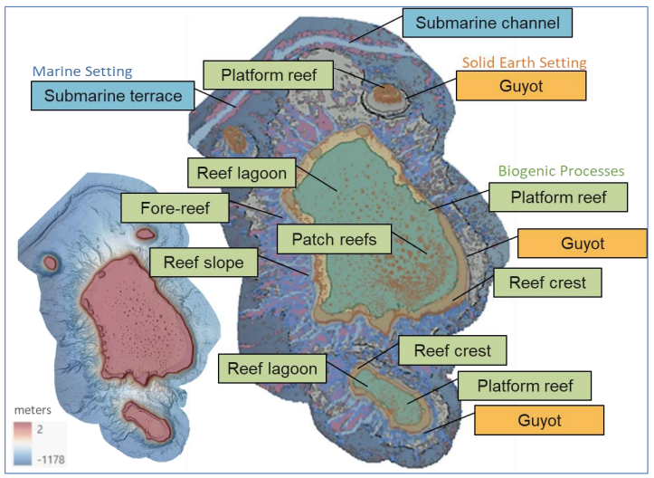
This standardised, multi-scalar and inter-jurisdictional two-part mapping method can be applied locally, regionally, and internationally. We are already applying it with Parks Australia to better understand the potential distribution and diversity of key seabed habitats in Australia’s Marine Parks, including habitats associated with the seamount and platform features of North Flinders Reef (Coral Sea Marine Park) (Figure 2). We look forward to seeing the approach implemented by the seabed mapping community and welcome your feedback.
Rachel Nanson, Mardi McNeil and Andrew Carroll
Geoscience Australia
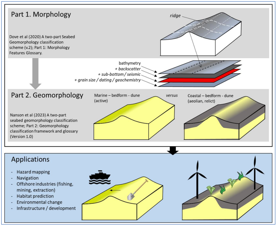
Dove, D., Nanson, R., Bjarnadóttir, L.R., Guinan,J. , Gafeira, J., Post, A., Dolan, M.F.J., Stewart, H., Arosio, R., Scott, G., 2020. A two-part seabed geomorphology classification scheme (v.2); Part 1: morphology features glossary. https://zenodo.org/record/4071940
Nanson, R., Arosio, R., Gafeira, J., McNeil, M., Dove, D., Bjarnadóttir, L., Dolan, M.F.J., Guinan, J., Post, A., Webb, J.and S. Nichol. 2022. A two-part seabed geomorphology classification scheme. Part 2: Geomorphology classification framework and glossary. https://zenodo.org/record/7804019